

A geodynamic model of the modern Earth is constructed based on the SMEAN 2 global seismic tomography model with an emphasis on the Arctic region. For a spherical Earth model, a solution of the Stokes equation for a viscous fluid was obtained based on seismic tomography data using the CitcomS code. The resulting distributions of temperature anomalies and velocity fields of mantle flows explain the main features of the modern geodynamics of the Arctic region.
More“Global Geodynamic Model of the Earth and Its Application to the Arctic Region”Number of Aftershocks in Epidemic-type Seismicity Models and reality
About the article by G. Molchan published in Geophys. J. Int.,239 (2024).
The widely used ETAS seismicity model describes the clustering of seismic events as an epidemic-type process (property A), assuming that the F1 distribution of the number of direct aftershocks is Poisson (property B). The real data favor the geometric distributions F1 (Shebalin et al., 2018). The F2 distribution of the number of all events in a cluster with relative magnitude (relative to the main shock) greater than – Δ is often also associated with geometric type However, the coincidence of distribution types F1 and F2 turns out to be in contradiction with the A-property, and the geometric type F1 is in contradiction with the B-property.
More“Number of Aftershocks in Epidemic-type Seismicity Models and reality”The Deepest Depressions on Land in Antarctica as a Result of Cenosoic Riftogenesis Activation
New subglacial BEDMACHINE model shows the presence of a large number of narrow and deep bedrock depressions in various regions of Antarctica with depths up to 3500 m below sea level (Denman Depression).
More“The Deepest Depressions on Land in Antarctica as a Result of Cenosoic Riftogenesis Activation”Thermal state of the lithosphere beneath The Laptev Sea: Geodinamic implications from geomagnetic data
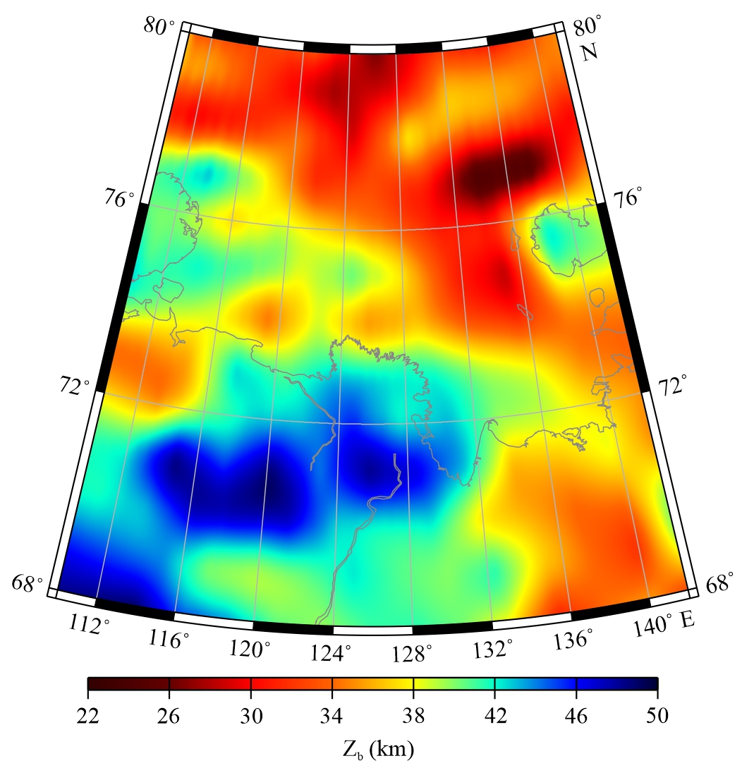
The Laptev Sea is a unique region, representing a transition zone from the spreading Gakkel Ridge to the rift system, located on the continental margin of Eurasia. In this study, we construct high-resolution distributions of the depths to the top and bottom of the lithospheric magnetic layer (LML) for the Laptev Sea and adjacent areas using the centroid method and the EMAG2v3 model of the lithospheric magnetic field. Maximum bottom depths of the LML (45–48 km) are observed under the Siberian Platform, in the north of the Verkhoyansk Range, and under the Lena River delta and Buor-Khaya Bay, while the shallowest bottom depths (<34 km) are attributed to the Eurasia Basin and eastern Laptev Sea. Our results indicate that the coldest lithosphere is attributed to the Siberian Platform. The lithospheric heating is observed under the Eurasia Basin and eastern Laptev Sea; the western part of the shelf, Buor-Khaya Bay, and Lena River delta are characterized by the colder lithosphere. The eastern segment of the Khatanga-Lomonosov Fracture is characterized by a local temperature minimum. An area of relatively high temperatures in the east of the shelf passes to the continent through the Yana Bay and covers the Yana-Indigirka lowland. This fact along with the crustal thinning and extension allow us to suggest rifting processes in the considered area.
Potential Locations of Strong Earthquakes in Bulgaria and the Neighbouring Regions
Information about potential earthquake sources is a key issue for seismic hazard assessment. This study presents the application of a phenomenological approach based on pattern recognition to determine the possible locations of strong earthquakes in the Bulgarian region. The technique assumes the origin of strong earthquakes in morphostructural nodes formed around the intersections of morphostructural lineaments identified by morphostructural zoning.
More“Potential Locations of Strong Earthquakes in Bulgaria and the Neighbouring Regions”
The largest earthquakes in subduction zones around the Polar Regions.
A correlation is observed between changes in the level of Earth’s seismic activity and increments of the atmospheric methane concentration over the past 40 years.
More“The largest earthquakes in subduction zones around the Polar Regions.”Inverse scattering – Fourier analysis – super-resolution
The paper “Numerical reconstruction from the Fourier transform on the ball using prolate spheroidal wave functions” was published in “Inverse Problems” (Q1 WoS) journal. Doctor of physical and mathematical sciences R.G. Novikov is one of the authors of this article.
More“Inverse scattering – Fourier analysis – super-resolution”