

Global test for real-time prediction of the world’s strongest earthquakes Morphostructural zonation and earthquake-prone areas QGIS-project for Seismic Hazard Assessment based on the Unified Scaling Law for Earthquakes: Lake Baikal region
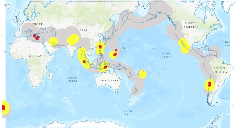
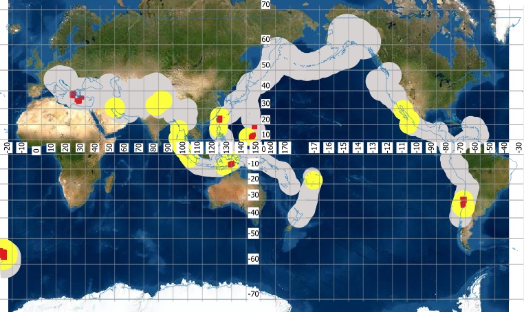
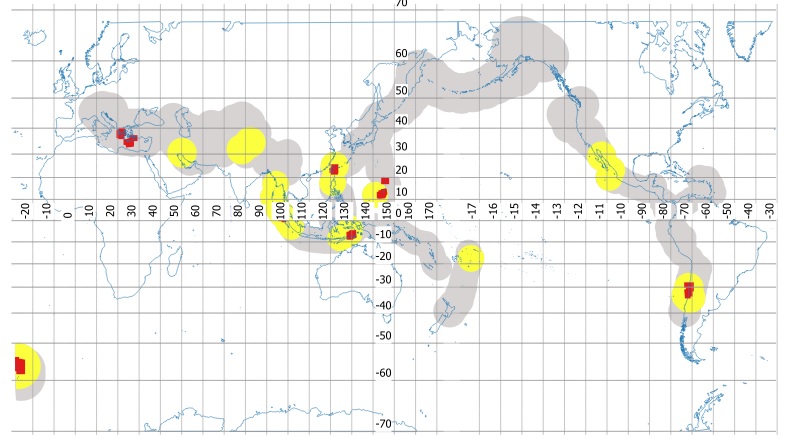
Global test for real-time prediction of the world’s strongest earthquakes
For the past 30 years, the M8 medium-term earthquake prediction algorithm has been applied globally every six months in real time for identifying the areas where the world’s strongest earthquakes are most likely to occur. As of now, the statistics of the outcomes observed in the Global Test with a confidence exceeding 99% indicates fairly high efficiency of the forecasts based on the M8 algorithm and those based on its combination with the MSc algorithm which more accurately localizes the focal zone of the expected earthquake. Thus, the null hypothesis of random occurrence in seismically active areas is rejected with seismologically certainty at least for the world’s strongest earthquakes in the magnitude ranges 8.0+ and 7.5+. The results of this experimental testing indirectly confirm the predictability of the strong earthquakes and the existence of both the common dynamic characteristics and diverse behavior during phase transitions in a complex hierarchical nonlinear fault-and-block system in the Earth’s lithosphere.
Ismail-Zadeh A., Kossobokov V. Earthquake Prediction, M8 Algorithm // Encyclopedia of Solid Earth Geophysics. Encyclopedia of Earth Sciences Series / Gupta H. (ed). Springer, Cham, 2021. P. 204-208. DOI:10.1007/978-3-030-10475-7_157-1
Kossobokov V.G., Shchepalina P.D. Times of Increased Probabilities for Occurrence of World’s Largest Earthquakes: 30 Years Hypothesis Testing in Real Time // Izvestiya, Physics of the Solid Earth. 2020. V. 56. № 1. P. 36-44. DOI:10.1134/S1069351320010061
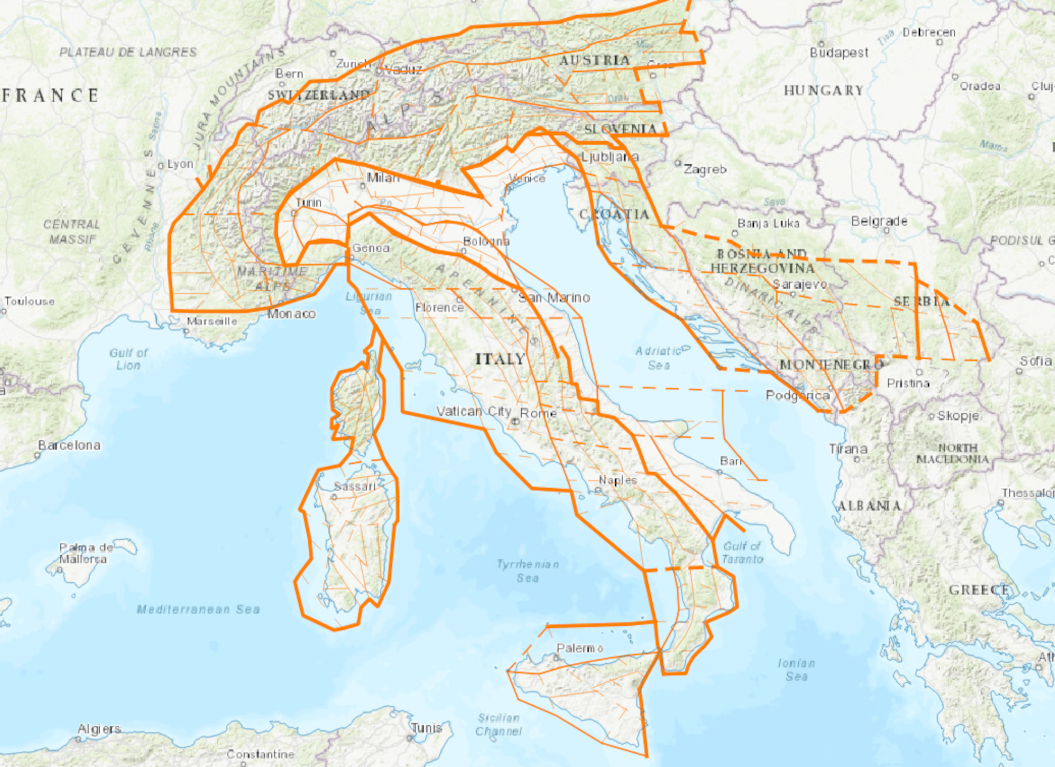
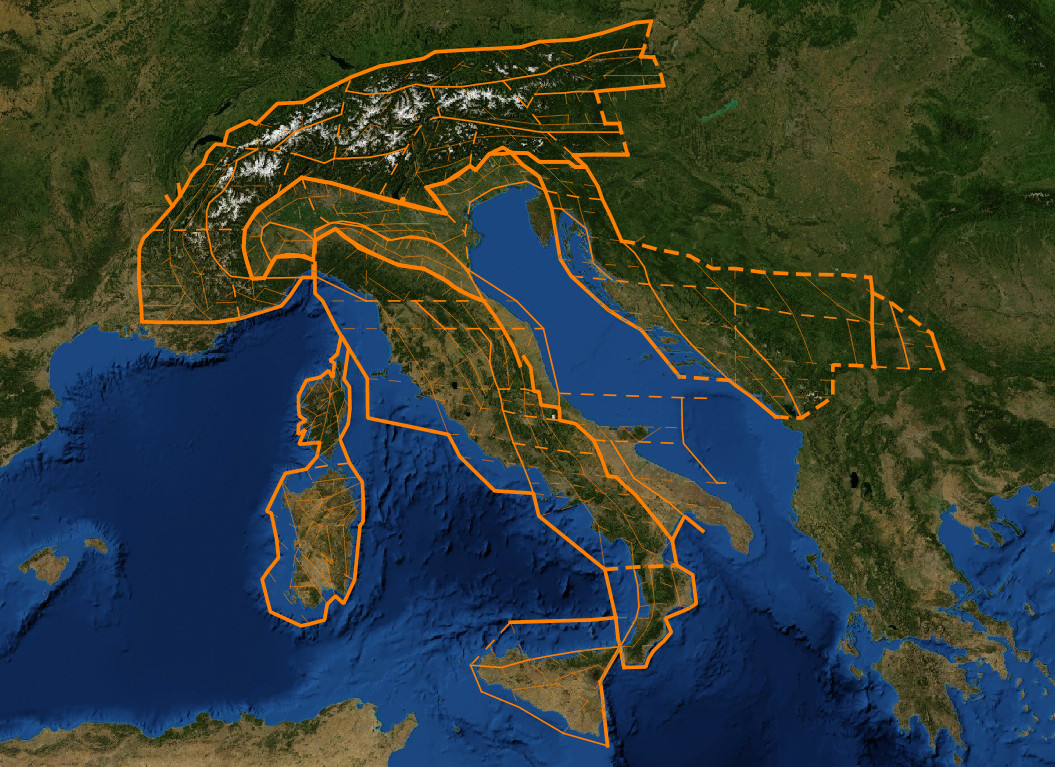
Morphostructural zonation and earthquake-prone areas
“Lineaments and places of possible strongest earthquakes’ occurrence” project summarizes the results on the recognition of places of strong earthquakes’ possible occurrence within Italian region [Gorshkov et al., 2002, 2003, 2004, 2009]. The studies have shown that strong earthquakes confined to the intersections of tectonically active fault zones – morphostructural nodes. Location of nodes is determined by the method of morphostructural zoning. The pattern recognition algorithms are performing classification of nodes by seismic hazard degree.
The highly seismic Black-Sea–Caspian region contains conjugate mountain edifices of the Caucasus, Alborz, and Kopet Dagh, the Rioni and Kura intermontane troughs, and the deep southern Caspian basin. Potential sites of larger (М ≥ 7.0) earthquakes in the region have been defined by (Novikova and Gorshkov, 2018). This was done using the methodology designed for identification of sites of possible large earthquakes. The earthquake-generating features are considered to be intersections of morphostructural lineaments as identified by morphostructural zoning. The epicenters of М ≥ 7.0 earthquakes correlate with lineament intersections. The Kora-3 pattern recognition algorithm was used to separate all intersections in the region into high- and low-seismicity ones with respect to М ≥ 7.0 based on the geological and geomorphologic parameters that characterize vicinities of intersections. The result was to recognize 150 intersections as having potential for М ≥ 7.0 earthquakes of a total of 510 intersections that were found in the region by morphostructural zoning. All of these intersections are within mountain belts. No intersections that can generate М ≥ 7.0 earthquakes have been identified in the intermontane troughs and within the southern Caspian deep-sea basin, whose crust is thinner. According to the geological and geomorphologic features of high seismicity intersections, as identified here, they are characterized by high contrasts in neotectonic movements and increased crustal fragmentation.
The French Massif Central, located within the West European platform, is characterized by a moderate level of seismicity. Seismogenic nodes capable of generating Io ≥ VI earthquakes were identified within it using a phenomenological approach based on pattern recognition. Recognition objects – morphostructural nodes – are identified using the morphostructural zoning method allowing to delineate the hierarchical block structure of the region, represented by a system of morphostructural blocks, by lineaments limiting them, and nodes that are formed at the intersection of lineaments. The epicenters of earthquakes Io ≥ VI are confined to some nodes. The CORA-3 recognition algorithm has identified other nodes where earthquakes of this intensity have not yet been registered. Recognized seismogenic nodes are located mainly in the eastern part of the massif and correlate with lineaments of higher ranks separating the largest blocks. As a result, information was obtained on potential sources of earthquakes, which is very important for a long-term assessment of seismic hazard.
Seismogenic nodes capable of earthquakes with M5+ or Iо ≥ VII have been identified in the Iberian Peninsula using the pattern recognition approach. Recognition objects, morphostructural nodes, have been delineated with the morphostructural zoning method. Most of the recognized seismogenic nodes are scattered at the periphery of the Peninsula, while in its internal part, apart from the northern part of the Iberian Chain, there is no indication for the existence of seismogenic nodes. The performed recognition pinpoints a number of seismogenic nodes where moderate events have not been recorded to date, specifically, in the Cantabrian Mts, Portuguese basin, westernmost termination of the Betics, and in the area around Valencia. Some of the recognized seismogenic nodes are potential sources of seismic risk for nuclear and water power plants and large metropolitan areas.
Geological and geomorphological criteria for the areas prone to the earthquakes with magnitudes M ≥ 7.0 are determined for the territory of the Hellenides located in the southern part of the Balkan Peninsula. Intersections of morphostructural lineaments identified by the morphostructural zoning method are considered as seismogenic structures. Geological and geomorphological parameters were determined in a unified manner for all lineament intersections. It is established that earthquake epicenters with М ≥ 7.0 are confined to the intersections of lineaments. The intersections associated with the observed earthquakes with М ≥ 7.0 are used for training the recognition algorithm Cora-3. Based on the geological and geomorphic parameters, the recognition algorithm revealed the characteristic traits according to which all the lineament intersections were classified into the highly seismic (H) (historically called as dangerous, D) and low seismic (historically called non-dangerous (N)) relative to the threshold magnitude М0 = 7.0. As a result, all these intersections were recognized as dangerous, just as another 24 intersections at which the events with magnitude M ≥ 7.0 have not been previously observed. In particular, these intersections are recognized on the Evia Island where the western branch of the North Anatolian fault approaches the coast of Central Greece. Another group of D-intersections is located in the central part of the Gulf of Corinth, the tectonically most active area of the region where, however, the earthquakes with M ≥7.0 have not been detected so far. The characteristic traits of D- and N-intersections (seismicity criteria) are formed by the morphometric parameters. The intervals of values of these parameters that are characteristic of D-intersections hint to the processes of subsidence and extension predominant in the areas of these intersections.
Information on potential earthquake sources is a key issue for seismic hazard assessment. The work presents an application of the phenomenological approach for identifying possible locations of strong earthquakes in the Bulgarian region. The methodology hypothesizes the nucleation of strong earthquakes at morphostructural nodes, forming at the intersections of morphostructural lineaments, which are detected by morphostructural zoning. Based on a wide set of geophysical and geological data characterizing nodes pattern recognition algorithm Cora-3 pinpointed capable nodes for M6+ in the Bulgarian region. Most of the recognized seismogenic nodes are located on the borders between the largest tectonic domains. They are boundaries between the Rila, Pirin, and Rhodope massifs, the Serbo-Macedonian, and the Rila-Pirin massifs as well as in the Stara Planina range. The set of characteristic features of seismogenic nodes established by recognition suggest the high contrast of neotectonic movements and the presence of deep heterogeneities in the earth’s crust in the vicinity of such nodes.
A single seismic zone of Southern Siberia, extending from Altai to the Pacific coast, which is located within the Central Asian mobile belt, is considered. The locations of the most powerful earthquakes in this region were determined using pattern recognition methods. The study is based on data from morphostructural zoning, uniformly carried out for the entire territory. The largest tectonic elements of the belt are Altai, Sayan Mountains, the Baikal Rift Zone, the Transbaikal Ranges region, the Stanovoye Highlands and the Stanovoi Range, as well as the Sikhote-Alin mountain range. Seismic activity within the belt is heterogeneous. In the Altai, Sayan and Baikal Rift Zone region, 20 M6+ events occurred. To the east of the Baikal rifts, seismic activity weakens: six events with magnitudes in the range of 6.0 – 6.4 were recorded here. According to the level of seismicity, the Central Asian mobile belt was divided into western and eastern parts. The western (region I) includes Altai, the Sayan Mountains and the Baikal Rift Zone, and the eastern (region II) includes the region of the Transbaikal Ranges, the Stanovoye Highlands, the Stanovoy Range and the Sikhote-Alin.
QGIS-project for Seismic Hazard Assessment based on the Unified Scaling Law for Earthquakes: Lake Baikal region
The project presents a GIS-based implementation of regional seismic hazard assessment for the Lake Baikal region based on the Unified Scaling Law for Earthquakes (USLE). Developed in QGIS, it incorporates USLE model input parameters (coefficients A, B, and C), estimates of Maximum Credible Magnitude for a 50-year time window with probabilities of exceedance 10%, 5%, and 1%, and an anisotropic representation of seismic impact propagation controlled by the geometry of active faults. The resulting outputs are maps of expected maximum macroseismic intensity. The project enables systematic comparison of the model results with the General Seismic Zonation (GSZ-2016) maps and the Global Seismic Hazard model (GEM-2023), as well as validation using a Specialized earthquake catalog for applications in national seismic zoning of the Russian Federation.
Authors: Anastasiya K. Nekrasova, Tatiana V. Prokhorova, Daria A. Krevsun
Project description:
File structure of the QGIS project ZIP archive ![]()
Logical data structure of the QGIS project. Roles and dependencies of layers ![]()
Structural organization of QGIS project blocks and parameters of the layers ![]()
Download project: QGIS_SHA_Project_using_the_USLE_Lake_Baikal_case_study.zip
Open a project on the NextGIS platform
Project related publications:
1. Кревсун Д.А., Некрасова А.К., Прохорова Т.В. ГИС-проект для оценки сейсмической опасности на основе Общего закона подобия для землетрясений: Прибайкалье // Современные методы оценки сейсмической опасности и прогноза землетрясений: Материалы докладов IV Всероссийской конференции (22–23 октября 2025 г., г. Москва). М.: ИТПЗ РАН, 2025. С. 88-89. EDN:WKFQIX ![]()
2. Krevsun D., Nekrasova A., Prokhorova T. GIS-Based Project for SHA using the Unified Scaling Law for Earthquakes, Lake Baikal Region case study // IAGA / IASPEI Joint Scientific Meeting 2025, 31 August – 5 September 2025, Lisbon, Portugal: Book of Abstracts. AS25-0097. Prague: CZECH-IN s. r. o., 2025. P. 1058. ![]() (poster)
(poster)