

To understand how geodynamic processes affect seismicity and what danger earthquakes pose in the Caucasus, a group of scientists from Russia, Azerbaijan, Armenia, Georgia, Germany, the Netherlands, the United States, and Switzerland conducted a study analyzing a large number of works on geology, geotectonics, geodesy, gravics, seismicity, seismic tomography, heat flow, magmatism, volcanism and its manifestations in the geological past in the Caucasus and determined the prospects for the development of research in the region. The paper was published in Earth-Science Reviews (Q1, JIF = 9.724).
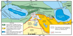
Correlation map of the main tectonic units of the Caucasus and surrounding areas
Being a part of ongoing continental collision between the Arabian and Eurasian plates, the Caucasus region is a remarkable site of moderate to strong seismicity, where devastating earthquakes caused significant losses of lives and property (Shamakhi earthquake, Azerbaijan, 1902; Spitak earthquake, Armenia, 1988; Rachin earthquake, Georgia, 1991). The Eastern part of the North Caucasus (Dagestan, Chechnya, Ingushetia, and North Ossetia) is also prone to earthquakes, with strong seismic events occurring in 1830 and 1970 in Dagestan, in 1976 in Chechnya, and in 1905 in Teberda.
This article examines the geology and geodynamics of the Caucasus and its surroundings, including its Paleozoic-Paleogene and post-collisional evolution to modern deformations; magmatism and heat flow; active tectonics and tectonic stresses caused by continental collision. Gravity models developed for the Caucasus and linking their specific features to the regional fault system, as well as recent geodetic studies related to regional movements are discussed. Regional seismicity is analyzed with an emphasis on subcortical seismicity under the Northern foothills of the Greater Caucasus. Recent seismic tomography studies support the separation of the lithospheric root under the Lesser and Greater Caucasus. Knowledge of geodynamics, seismicity, and stress conditions in the Caucasus region helps in assessing seismic hazard and risk. A review of earthquake modeling and seismic hazard studies providing a link between deep geodynamic and surface processes was conducted. The paper explores existing gaps in modern scientific knowledge of the Caucasus region and suggests ways to solve problems that can improve the understanding of regional evolution, active tectonics, geodynamics, crustal and deep seismicity, and surface manifestations of lithospheric dynamics. «A deep scientific understanding of geological and geophysical processes in the region will improve the assessment of seismic, volcanic and other natural hazards and lead to a reduction in the risk of natural disasters in the Caucasus» – says doctor of physical and mathematical sciences A.T. Ismail-Zadeh, chief researcher at the Institute of earthquake prediction theory and mathematical geophysics of the Russian Academy of Sciences and coauthor of the article.
Source: Ismail-Zadeh A., Adamia S., Chabukiani A., Chelidze T., Cloetingh S., Floyd M., Gorshkov A., Gvishiani A., Ismail-Zadeh T., Kaban M.K., Kadirov F., Karapetyan J., Kangarli T., Kiria J., Koulakov I., Mosar J., Mumladze T., Müller B., Sadradze N., Safarov R., Schilling F., Soloviev A. Geodynamics, seismicity, and seismic hazards of the Caucasus // Earth-Science Reviews. 2020. V. 207. Article 103222. DOI:10.1016/j.earscirev.2020.103222.